Highlights
- The summit & Sita Kund — Rock-cut tank, Jain temple, and a view across Anga to the Ganga..
- The serpent groove and Madhusudana image — On the ascent; look for the inscriptions..
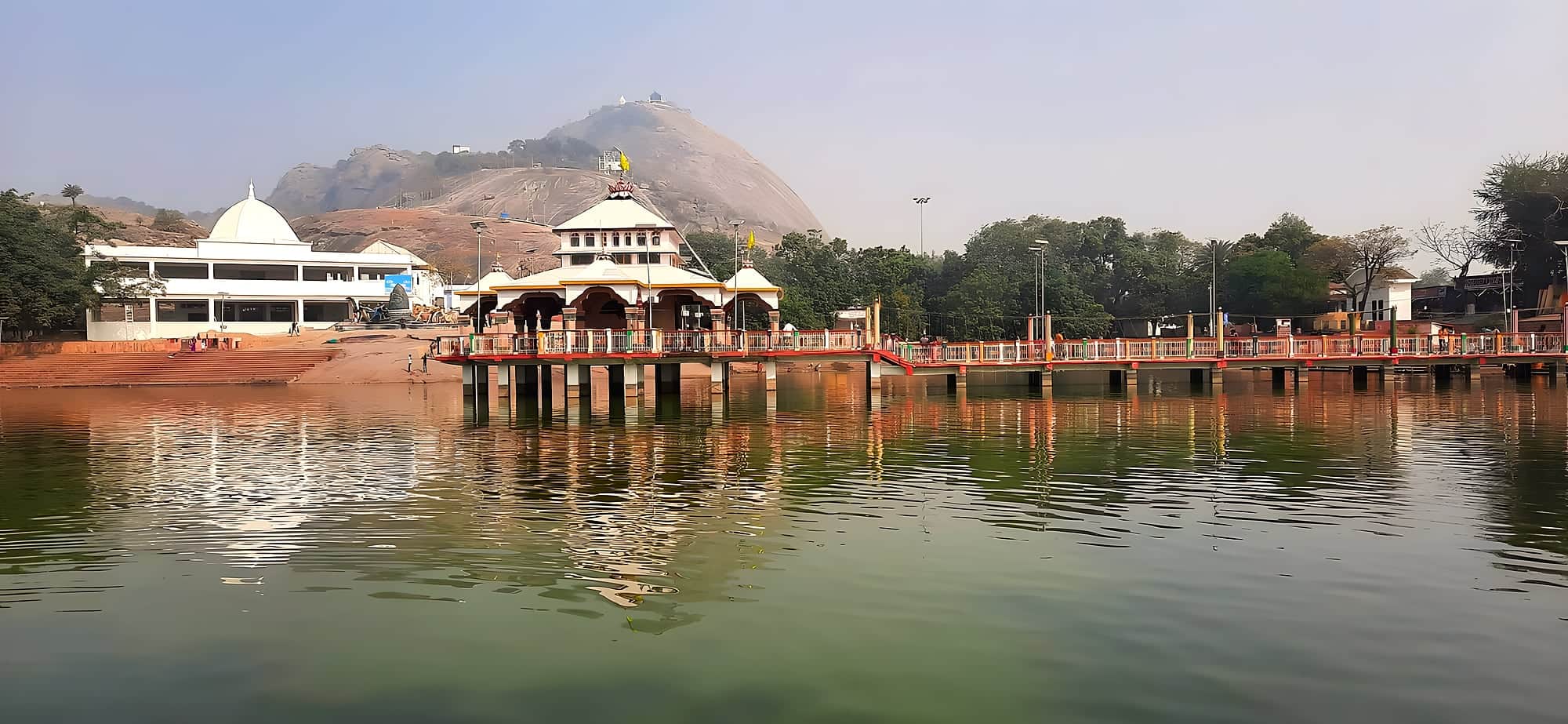
- Papharni tank — Lotus tank at the base with a temple on an island..
- Bounsi Mela — The January fair at Makar Sankranti..
In the Puranas the gods and demons used Mount Mandara as the churning-stick and the serpent Vasuki as the rope to churn the ocean of milk for nectar. A granite hill 45 km south of Bhagalpur has been identified with it since at least the Gupta period, and you can see why: it rises alone out of flat country, and a spiral groove around its upper part is read as the mark of the serpent.
The hill is sacred to Hindus and Jains alike. On the way up are Gupta-era inscriptions, a huge rock-cut image of Madhusudana (Vishnu), a Shiva lingam, Jain footprints of Vasupujya — the 12th tirthankara, believed to have attained nirvana here — and at the summit the Sita Kund, a rock-cut reservoir that never runs dry, with the Jain temple above.
A ropeway was opened in 2022 which makes the ascent easy; the stepped path takes about an hour. At the base is Papharni tank with a temple on an island, and the Madhusudana festival around Makar Sankranti in January fills the place with pilgrims and a fair.
Chapter 01
How it came to be
In the Puranas, Mandara is the mountain the gods and demons used as a churning-stick to churn the ocean of milk, with the serpent Vasuki as rope — and the single granite dome rising out of the Banka plain, with a groove spiralling round it that locals say is Vasuki's mark, has been identified as that mountain for two thousand years. Kalidasa mentions it; a 7th-century inscription of the Gupta king Adityasena records a Vishnu temple here.
For Jains, Mandar is where the 12th Tirthankara Vasupujya attained nirvana; a temple crowns the summit. For the Santhal people, who hold a huge Makar Sankranti fair at its foot, it is the hill of the Safa Hor reform movement. Three faiths, one rock.
Chapter 02
What it's like now
A new ropeway runs to the top in a few minutes, or you can climb the old pilgrim path — about an hour, past rock-cut inscriptions, carved figures and the Sita Kund and Shankh Kund pools. The summit has the Jain temple and a Shiva shrine and a view of the whole Anga country, flat and green, with the Ganga a silver line to the north.
At the foot, the Papharni tank with a temple on an island is where the Madhusudan image is bathed each Makar Sankranti before a fair that lasts a week. Bounsi town is a few kilometres away; Bhagalpur is the base.
Chapter 03
What to see
- 01
The summit & Sita Kund
Rock-cut tank, Jain temple, and a view across Anga to the Ganga.
- 02
The serpent groove and Madhusudana image
On the ascent; look for the inscriptions.
- 03
Papharni tank
Lotus tank at the base with a temple on an island.
- 04
Bounsi Mela
The January fair at Makar Sankranti.
Chapter 04
A perfect day
7:00
Leave Bhagalpur; at the hill by 8:30.
8:30
Climb the pilgrim path (or ropeway up, walk down) — the inscriptions and kunds.
10:00
Summit temples; the view over Anga.
12:00
Papharni tank and the island temple; lunch in Bounsi.
14:00
Return to Bhagalpur, or onward to Deoghar across the Jharkhand border (60 km).
Chapter 05
Stay, eat, celebrate
Where to stay
Bhagalpur or Banka; a Bihar Tourism guesthouse at the foot opens seasonally.
Where to eat
Stalls at the base during fairs; Bounsi dhabas; Bhagalpur for meals.
Festivals & seasons
Makar Sankranti mela (14 January, a week) — the great Santhal and Hindu fair; Vasupujya's nirvana day for Jains.
Practical
Getting there
Fly
Deoghar Airport (DGH) 60 km; Patna (PAT) 260 km.
Train
Mandar Hill station 3 km, on the Bhagalpur–Dumka line; Bhagalpur Junction 45 km.
Road
45 km south of Bhagalpur via Bounsi; 1.5 hours.
On the map · Mandar Hill is at 24.8389°N, 87.0458°E in Banka district, about 273 km (6½ h) by road from Patna.
Before you go · Best time to visit · Safety, dress code & money · What to eat nearby
Practical
Distances from Mandar Hill
Road distance and realistic driving time on Bihar roads — plan around these, not the straight line on a map.
From the gateway cities
| Bhagalpur → Mandar Hill | 59 km | 1 h |
| Darbhanga → Mandar Hill | 243 km | 6 h |
| Gaya → Mandar Hill | 269 km | 6½ h |
| Patna → Mandar Hill | 273 km | 6½ h |
| Muzaffarpur → Mandar Hill | 287 km | 7 h |
To nearby places
| Mandar Hill → Bhagalpur | 59 km | 1 h |
| Mandar Hill → Simultala | 70 km | 1½ h |
| Mandar Hill → Sultanganj | 72 km | 1½ h |
| Mandar Hill → Vikramshila | 77 km | 1½ h |
| Mandar Hill → Bhimbandh Wildlife Sanctuary | 89 km | 2 h |
| Mandar Hill → Munger | 108 km | 2½ h |
| Mandar Hill → Nagi & Nakti Bird Sanctuaries | 110 km | 2½ h |
| Mandar Hill → Ashok Dham, Lakhisarai | 134 km | 3 h |
| Mandar Hill → Kanwar Lake | 164 km | 4 h |
| Mandar Hill → Ugratara, Mahishi | 164 km | 4 h |
| Mandar Hill → Kusheshwar Asthan | 164 km | 4 h |
| Mandar Hill → Kakolat Falls | 187 km | 4½ h |
Estimates: road ≈ 1.3 × straight-line, ~40 km/h average. All Bihar distances →
Practical
Mandar Hill tickets, entry fee & timings
What visitors have been paying recently. Fees change without notice — treat these as a planning guide and check the official page where one exists.
Mandar Hill ropeway & Madhusudan temple
- Hours
- Ropeway ~9:00 – 17:00; temples open from dawn · closed Ropeway occasionally closed Mondays for maintenance — check locally
- Fee
- Ropeway return ~₹100–150 per person; children ~half. Temples free.
- Booking
- Counter at the base near Bounsi. Cash is safer than UPI here.